The "China Geological Survey Results Express" recently announced the main achievements of the "National Land Subsidence Remote Sensing Geological Survey and Monitoring" project.
The project was undertaken by the China Aero Geophysical Survey and Remote Sensing Center for Natural Resources of the China Geological Survey. Through implementation of the project, InSAR technology was used to continuously carry out annual land subsidence monitoring in the three key subsidence areas—the Beijing-Tianjin-Hebei coordinated development region, the Fenwei Basin, and the Yangtze River Delta—grasping the development trends of land subsidence in key regions and directly reflecting the development patterns and prevention and control effects of regional land subsidence; at the same time, baseline surveys of land subsidence were carried out in nationwide subsidence-prone areas, groundwater overexploitation areas, and coastal cities, forming a single map of China's current land subsidence status that effectively covers plains, basins, deltas, and other areas susceptible to land subsidence, thereby clarifying the land subsidence conditions in China.
The national land subsidence conditions were basically ascertained. The project achieved full coverage of land subsidence in existing work areas and supplementary survey areas, and researched and compiled the "Map of Current Land Subsidence in China," with an effective coverage area of approximately 2.16 million square kilometers, clarifying the current status of land subsidence in China. Large-scale regional land subsidence was discovered in some groundwater overexploitation areas, revealing the basic characteristics of the occurrence and development of land subsidence in China today.
The annual dynamic change characteristics of key land subsidence prevention and control areas were comprehensively grasped. The project continuously carried out annual dynamic monitoring in the three key subsidence areas—the Beijing-Tianjin-Hebei coordinated development region, the Fenwei Basin, and the Yangtze River Delta region—achieving comprehensive control over the annual dynamic changes in key subsidence areas, clarifying the development characteristics and change trends of land subsidence in each region, and reflecting the effectiveness of land subsidence prevention and control in each area.
A regional relationship model between land subsidence and groundwater extraction volume was preliminarily constructed. The main cause of regional land subsidence in the Beijing-Tianjin-Hebei coordinated development region is the extraction and utilization of groundwater and other fluid resources, and the land subsidence caused by groundwater extraction is closely related to the hydrogeological conditions of the region. In the work, the project team conducted research on the spatiotemporal correlation between land subsidence and regional geology, industrial structure, and groundwater extraction in Beijing and Hengshui as study areas, and preliminarily constructed a relationship model between annual land subsidence obtained based on InSAR technology and the maximum groundwater head drawdown over a certain period, providing a scientific basis for the next steps in land subsidence prevention and control work and measures such as groundwater extraction control.
Key sections for land subsidence prevention and control along linear engineering routes were scientifically delineated. Large linear projects such as high-speed railways, expressways, and the eastern route of the South-to-North Water Diversion Project passing through the North China Plain traverse severe land subsidence areas. The annual land subsidence monitoring work in key areas clarified the segmental differences and development trends of subsidence fields along the routes, providing basic data for route selection of major linear projects and subsidence prevention and control countermeasures in major sections.
The regional land subsidence InSAR survey and monitoring work system was continuously improved. In response to the continuous advancement of InSAR technology and imaging radar technology, the project team gradually improved the regional land subsidence InSAR survey and monitoring work system, analyzed the applicability of multi-source SAR data and methods, and made full use of multi-source data to expand related deformation survey and monitoring applications; the developed TCP-based InSAR time-series analysis method under high-frequency observation conditions and its application demonstration realized the transformation of technical methods from regional land subsidence field surveys to target monitoring.
Sunward Intelligent AI Project Selected for the 2023 List of Key 'Three Transformations' Projects for Manufacturing Digital Transformation in Hunan Province
下一篇Equivalent to the Height of a 65-Story Building! The Sichuan-Side Main Tower of the Kahaluo Jinsha River Bridge on the Yanjiang Expressway Successfully Tops Out
2026-09-28 1157 0
2026-09-24 10586 0
2026-09-23 10714 0
2026-09-22 10808 0

Lize City Air Terminal Underground Main Structure Nearing Completion: Maximum Transfer Walk Under 4 Minutes After Operation

Anti-seepage Curtain for Main Lock Pit of CSCEC Port Shenqiu Double-Line Lock Project Completed on Schedule

All Pile Foundations Completed on Quanzhou Baiqi Channel

Hainan Upgrades Housing and Municipal Infrastructure
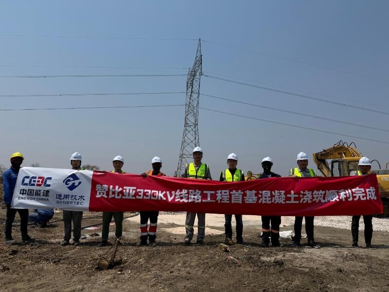
First Foundation Concrete Pour Successfully Completed for Zambia Kafue West–Muzuma 330kV Transmission Line EPC Project
Hot News

评论 (0)